Paragliders share the sky with airliners, military helicopters, drones and balloons. That sky is divided into airspace with its own rules: who may enter where, whose permission is needed, how to communicate, how high you may go. A paraglider pilot doesn't need to know everything an air traffic controller knows, but does need to know which class of airspace they are in and where its boundaries are – because straying into controlled airspace is the most serious violation a pilot can commit, even in perfect weather. This article summarises how the world (ICAO) classifies airspace, how Vietnam applies it, and what applies directly to paragliding.

1. Why airspace is classified
Aircraft fly under two sets of rules: IFR (instrument flight rules – commercial aviation, flying in cloud, guided by ATC) and VFR (visual flight rules – seeing the ground and other aircraft to avoid them yourself). Paragliders, sailplanes, paramotors and balloons all fly VFR, and are the slowest VFR traffic there is, with no mandatory radio and no transponder. Airspace classification answers the question: in this piece of sky, does ATC separate aircraft or merely inform them about each other, and is VFR allowed in at all.
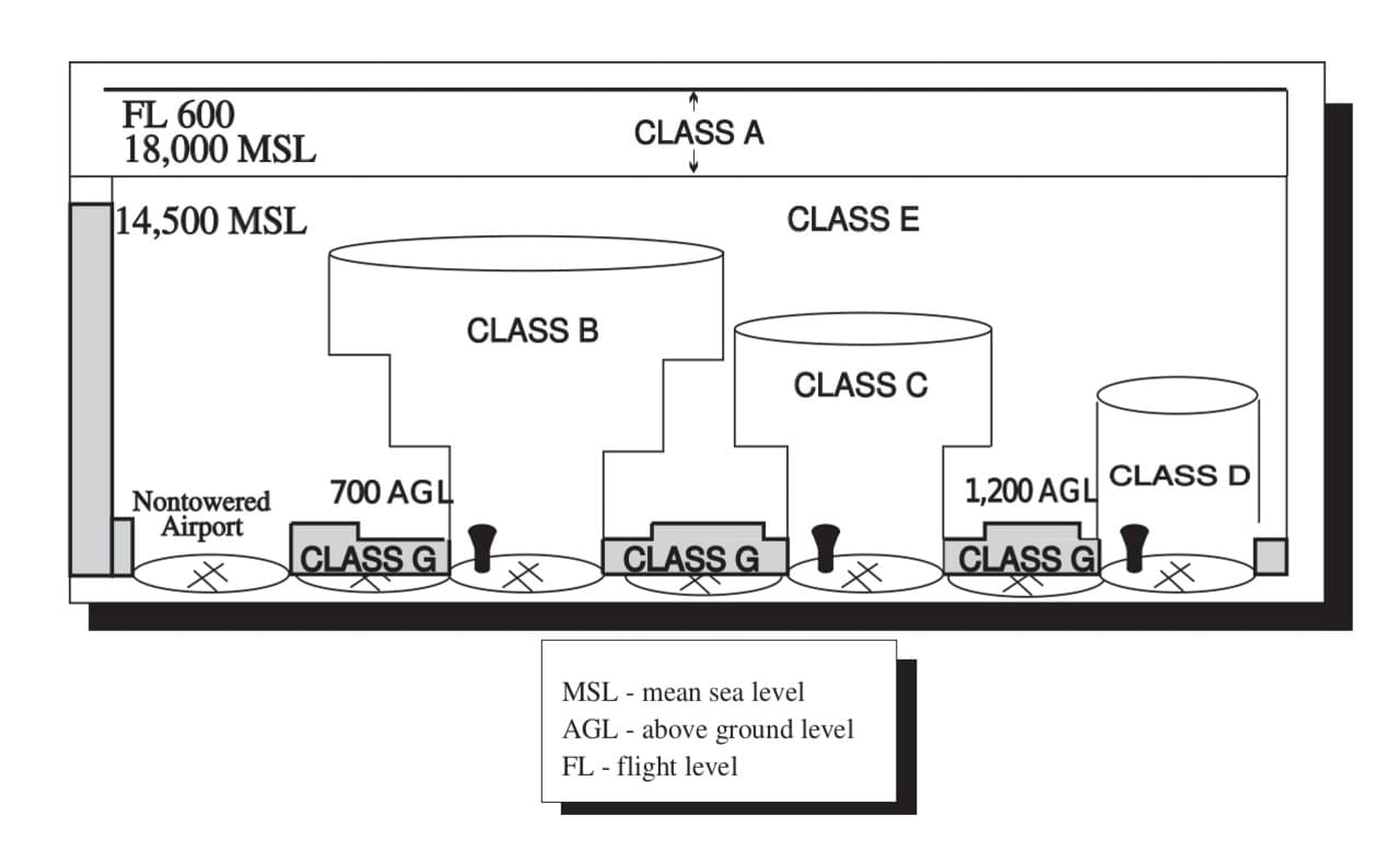
2. The seven ICAO airspace classes (Annex 11)
ICAO defines seven classes, from the most tightly controlled (A) to uncontrolled (G). Each country chooses which classes to use where.
| Class | Controlled | IFR | VFR | Can a paraglider enter |
|---|---|---|---|---|
| A | Yes | Separated from all traffic | VFR prohibited | Never |
| B | Yes | Separated from all traffic | Allowed, separated from all traffic, clearance required | Only with ATC clearance – in practice no |
| C | Yes | Separated from IFR and VFR | Separated from IFR, traffic info on other VFR; radio + clearance required | Only with clearance; in practice no |
| D | Yes | Separated from IFR, traffic info on VFR | Traffic information only; radio + clearance required | Only with clearance |
| E | Yes | Separated from IFR | No clearance, no mandatory radio; traffic info where practical | Yes, avoiding IFR visually and keeping clear of cloud |
| F | Advisory | Advisory service | Flight information | Yes (few countries still use it) |
| G | No | Flight information only | Flight information only, no radio, no clearance | Yes – this is the paraglider's home |
Two points that matter for paragliding:
- VFR is only legal in VMC (visual meteorological conditions). Per ICAO, below 3,050 m (10,000 ft): visibility ≥ 5 km, 1,500 m horizontally and 300 m vertically from cloud. In class G below 900 m (3,000 ft) or below 300 m above terrain: only clear of cloud and in sight of the surface. Flying right under cloudbase or entering cloud is not just dangerous, it is illegal.
- Class E is the trap: it looks free (no radio, no clearance) but IFR traffic passes through it, and IFR aircraft may be in cloud and unable to see you. The 300 m vertical / 1,500 m horizontal cloud clearance in class E exists so they have time to see you when they pop out.

3. Named zones inside the classes
Besides classes A–G, aviation charts draw zones with specific purposes. International designators (Vietnam uses the prefix VV):
| Designator | Name | Meaning for paragliding |
|---|---|---|
| FIR | Flight Information Region | The largest unit; Vietnam has two: Hanoi FIR and Ho Chi Minh FIR |
| CTR | Control Zone | From the ground up to a set altitude around an airport, usually 10–20 km radius. Stay out |
| TMA | Terminal Control Area | Larger than the CTR, floor a few hundred metres up – arriving and departing traffic. Stay out |
| ATZ | Aerodrome Traffic Zone | Around small aerodromes; contact the tower |
| AWY | Airway | Corridor for cruising traffic, class C in Vietnam; the airway floor is usually a few thousand metres – XC pilots must know where the floor is |
| P | Prohibited, e.g. VVP-xx | Absolutely forbidden at all altitudes (military sites, key government buildings) |
| R | Restricted, VVR-xx | Enter only with permission, usually with operating hours |
| D | Danger, VVD-xx | Hazardous activity (live firing, weapons tests); you may fly through at your own risk |
| TRA / TSA | Temporary Reserved / Segregated Area | Activated by NOTAM, usually military |
| NOTAM | Notice to Airmen | Temporary changes: airport closures, temporary prohibited areas, military exercises – read before every XC day |

4. How Vietnam classifies its airspace
Vietnam applies five classes: A, C, D, E, G (per AIP Vietnam, ENR 1.4, 2023 edition – pilots should check the latest at aim.vatm.vn).
| Class | Where in Vietnam | Meaning for paragliding |
|---|---|---|
| A | Hanoi and Ho Chi Minh FIRs, roughly 6,000–14,000 m | Irrelevant – paragliders don't get there |
| C | Airways from minimum flight level to 6,000 m; Noi Bai and Tan Son Nhat TMAs; Noi Bai, Tan Son Nhat and Da Nang CTRs | Stay out. Airway floors and TMA boundaries cap the sites near Hanoi (Bu Hill, Vien Nam) and Da Nang (Son Tra) |
| D | Tower areas of other civil airports (Cat Bi, Vinh, Phu Bai, Cam Ranh, Lien Khuong, Phu Quoc…) | Stay out without permission; sites near Da Lat and Nha Trang take note |
| E | Within the FIRs outside airways and TMAs, from 2,000 m to 6,000 m; aerodrome transition areas | Flyable in principle, but above 2,000 m you are in the IFR layer |
| G | The remaining airspace, broadly below 2,000 m outside CTR/TMA; CTRs outside operating hours | Where almost all paragliding happens |
The biggest difference from many countries: in Vietnam all airspace is managed centrally by the Ministry of National Defence; civil aviation (the CAAV and VATM) runs civil routes and airports within that framework. So paragliding in class G is not free the way it is in Europe – a flight permit is still required (section 5).
Reading real AIP charts: Noi Bai and Tan Son Nhat
The classification table above is abstract. The charts in AIP Vietnam (part AD 2, the chart set for each airport) show how low IFR traffic actually flies around our sites. The three charts below are public documents of the Civil Aviation Authority of Vietnam. Click an image to see it full size.
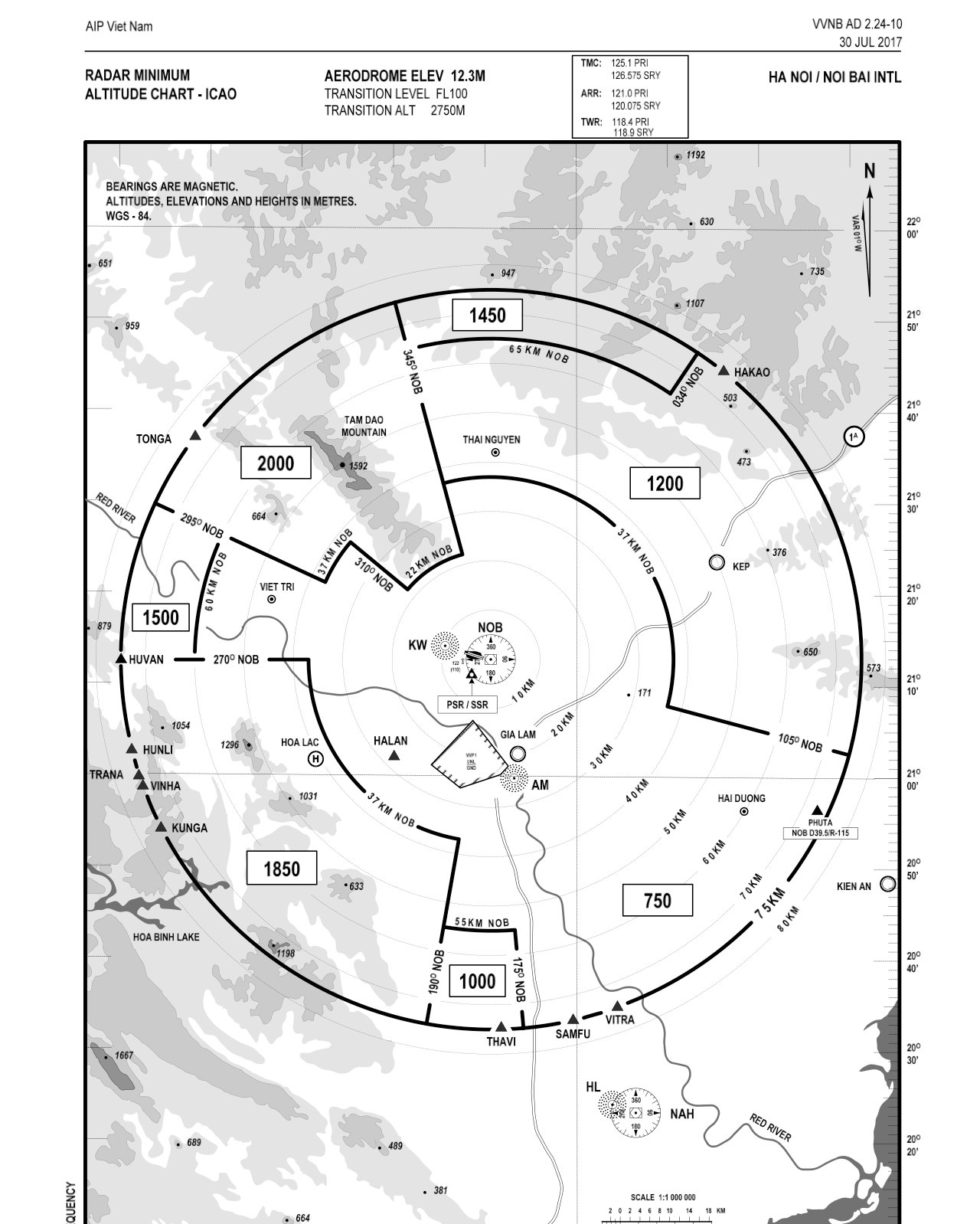
The Noi Bai radar minimum altitude chart (RMAC) splits the 75 km radius around the NOB beacon into sectors. The number in each (in metres) is the lowest altitude a controller may vector IFR traffic: 750 m to the south-east, 1,000 m south, 1,200 m north-east, 1,450 m north, 1,500 m west, 1,850 m south-west (towards Hoa Lac and Ba Vi) and 2,000 m north-west, where Tam Dao rises to 1,592 m. Two lessons for northern Vietnamese pilots:
- Sites south-west of Hanoi such as Vien Nam and Bu Hill sit in or next to the 1,850 m sector. On a good day an 1,800–2,000 m thermal top is normal, which means you can climb to the same level as IFR traffic being vectored overhead. That is why the permitted ceiling at these sites is kept low.
- The small trapezoid over central Hanoi reads VVP1, UNL/GND: a prohibited area from the ground to unlimited over the capital.
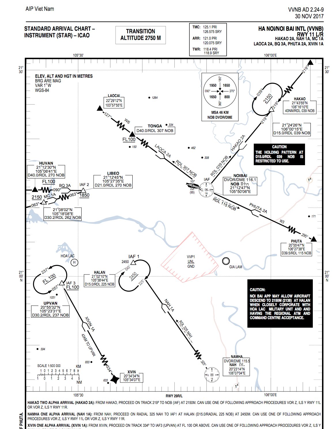
The runway 11 standard arrival chart (STAR) shows where airliners really go. The NAH 1A arrival from Nam Ha tracks to HALAN (the Quoc Oai – Hoa Lac area) at 2,450 m, with a holding pattern there. A caution box adds that Noi Bai approach may allow aircraft down to 2,150 m at HALAN when coordinated with the Hoa Lac military unit. To the west, LIBEO sits at 1,850 m and the UPVAN hold at FL100. The transition altitude is 2,750 m: below it, aircraft set QNH, just like your vario.
In other words, the sky over the sites around Hanoi is not empty. The ground may be class G, but a few hundred metres of extra climb puts you under, or in, the approach path to the airport.
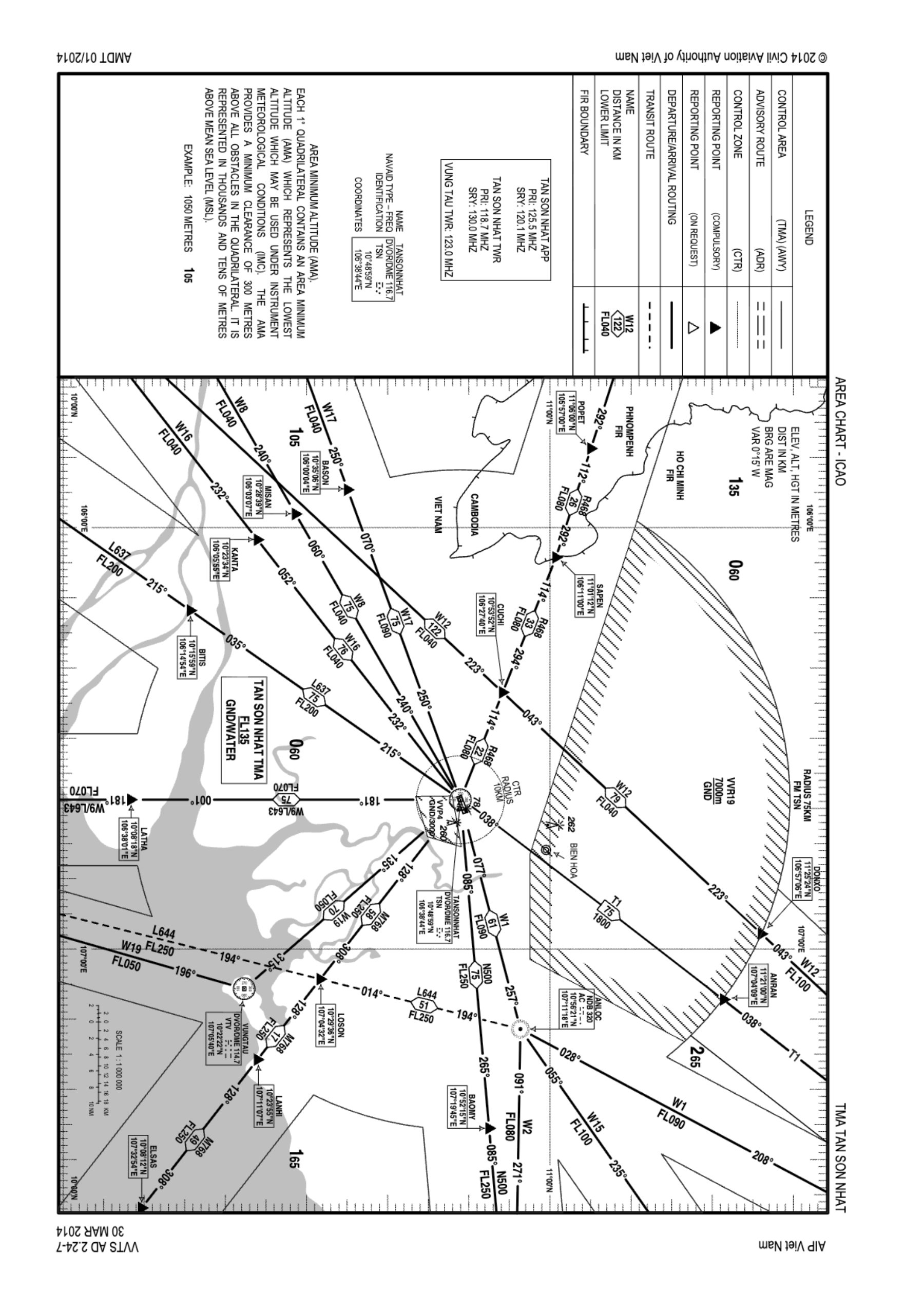
The Tan Son Nhat TMA area chart illustrates almost every concept in this article:
- Tan Son Nhat TMA: from ground/water (GND/WATER) up to FL135, reaching out to Vung Tau, Bien Hoa and the Cambodian border.
- Tan Son Nhat CTR: a 10 km radius circle around the TSN DVOR/DME, from the surface to 750 m, class C, run by Tan Son Nhat Tower (AIP VVTS AD 2.17). Transition altitude 2,750 m, as at Noi Bai.
- VVR19 (hatched): a restricted area from the ground to 7,000 m, 75 km radius. The R in the name marks a restricted area – enter only with permission.
- The large numbers in the corner of each grid square (for example 060, 105, 135) are area minimum altitudes (AMA) in tens of metres: 105 means 1,050 m, giving at least 300 m clearance over every obstacle in that square.
These charts are dated 2014–2017 and are shown only to teach how to read them. For current limits, check the latest AIP at aim.vatm.vn and ask the site operator.

5. The law that applies to paragliding in Vietnam
A paraglider is an "other flying vehicle"
The People's Air Defence Law 2024 (No. 49/2024/QH15, in force 1 July 2025) divides flying devices other than civil aircraft into unmanned aircraft and other flying vehicles – balloons, model aircraft, parachute-wings, kites and other flying devices. Paragliders, paramotors (PPG) and hang gliders fall in this group. The law replaces the old regime under Decree 36/2008 on "ultralight flying vehicles".
Who issues flight permits
Decree 288/2025/NĐ-CP (in force 5 November 2025) sets the detail: the Ministry of National Defence (through the Operations Department of the General Staff) issues flight permits for unmanned aircraft and other flying vehicles in Vietnamese airspace. The file includes an application, proof of lawful ownership and a sketch of the flying area; it is lodged at least 7 days before the flight, and the authority answers within 5 working days. A standard permit is valid up to 30 days; a traditional flying area – a regular, established activity such as a recognised paragliding site – can be permitted for up to 360 days. This is the mechanism clubs and site operators use to obtain yearly permission.
The permit states: the area (coordinates, radius), maximum altitude, hours of the day, number and type of vehicles, and the responsible person. Flying outside these parameters is flying without a permit.
Prohibited and restricted areas
Prime Minister's Decision 18/2020/QĐ-TTg established prohibited and restricted areas for unmanned aircraft and ultralight vehicles (this decision is being reviewed for replacement under the new law – check its status before quoting):
- Prohibited: defence works and especially important military areas (≥ 500 m from the boundary at any altitude); offices of the Party, State, National Assembly, Government and provincial equivalents (≥ 200 m); garrisons, depots, bases (≥ 500 m); airports: a rectangle extending 15,000 m beyond both runway ends and 5,000 m to each side; and airways per the AIP.
- Restricted: airspace higher than 120 m above terrain (flying higher requires a permit stating the altitude); crowded areas; the border strip (10–25 km depending on the sector); the zone adjoining airports (3–5 km outside the prohibited area).
For paragliding, that 120 m figure explains why every site needs its own permit: almost no paragliding flight stays below 120 m above terrain.
Requirements for the pilot
The person in direct control must be at least 18, have full civil capacity and, for vehicle types that require it, hold an operating licence/certificate. A permit can be suspended for flying outside its terms, outside the area or altitude, or for defence and security reasons. The operator must comply with a stop-flying order immediately.
In practice at Vietnamese sites
- Each site (Khau Pha, Sapa, Bu Hill, Vien Nam, Son Tra, Phinh Ho…) operates under a permit obtained by the site operator; visiting pilots must fly within the area, hours and ceiling stated in that permit, and register with the operator before flying.
- The real ceiling in the permit is usually far lower than the theoretical class G ceiling. Busting it on a good thermal day violates the whole site's permit, not just your own.
- An XC flight leaving the permitted area is an unpermitted flight even if you remain in class G. XC requires a permit for a specific corridor and date.
- Near military airfields (Yen Bai, Tho Xuan, Kep, Phu Cat, Bien Hoa…) and firing ranges, permits can be suspended at short notice by the training schedule – the site operator receives the notice and must stop flying immediately.

6. A quick comparison with other countries
| Country / region | Where paragliders fly | Notable points |
|---|---|---|
| Europe (EASA SERA rules) | Class G and E, no per-flight permit; avoid CTR/TMA; ceiling typically FL95–FL195 depending on the country | Public airspace maps loaded into instruments (XCTrack, Flyskyhy, OpenAIP); CTR busts are radar-tracked and heavily fined |
| USA (FAR Part 103 – ultralights) | Class G and E; B, C, D only with ATC permission; class A prohibited | No licence, no aircraft registration; daylight only; weight and speed limits |
| Switzerland, France, Austria | Class G/E; many sites sit right beside CTRs so have local ceilings and time-based "sensitive zones" | Federation-maintained paragliding maps (FFVL, SHV) updated daily with NOTAMs |
| Vietnam | Inside the area permitted by the Ministry of National Defence, mostly in class G | Every flight needs a permit (per site or per flight); no public paragliding airspace map yet – rely on the site operator |
7. What a pilot must do before every flight
- Know which class your site is in and where the nearest CTR/TMA/airway boundary is (ask the operator; check AIP ENR 2 and ENR 5).
- Know today's permitted ceiling and area; set an altitude alarm on your vario.
- If flying XC: check NOTAMs, obtain a corridor permit, load an airspace map into your instrument.
- Stay in VMC: clear of cloud, in sight of the ground; in class E keep 300 m below cloud.
- When a thermal carries you toward the ceiling: big ears, leave the core. The permit ceiling is a hard limit, not a suggestion.
- On a stop-flying order from the operator: land immediately, don't ask why in the air.
Airspace can't be seen, which makes it the easiest thing to forget on a beautiful day. Good pilots know their ceiling before they know whether today's thermals are good.
References
- ICAO Annex 11 – Air Traffic Services, Appendix 4: airspace classes A–G.
- AIP Viet Nam, part AD 2: VVNB AD 2.24-9, VVNB AD 2.24-10 (Noi Bai) and VVTS AD 2.17, VVTS AD 2.24-7 (Tan Son Nhat), Civil Aviation Authority of Vietnam.
- AIP Vietnam, ENR 1.4 – ATS airspace classification (VATM, 2023).
- People's Air Defence Law 2024, No. 49/2024/QH15.
- Decree 288/2025/NĐ-CP on the management of unmanned aircraft and other flying vehicles.
- Decision 18/2020/QĐ-TTg establishing prohibited and restricted areas.
Note: this article summarises the legal framework for pilots; it does not replace the legal texts or the site operator's instructions. Rules for other flying vehicles are changing quickly after the 2024 law – check the current texts before quoting.