When a thermal rises abruptly air from around the area rushes in to replace the thermal air. If this air is also heated it will be entrained by the thermal and rise into it. A vast source of heated air as in case III mentioned earlier will feed the thermal for several minutes creating a thermal column that stretches for thousands of feet (1000m). If the supply of warm air is limited, then cool air will replace the thermal which will then be of limited size. The cool air will take time to heat then will release as another thermal. The time for a thermal to form in this repetitive process may be from several minutes to an hour or more depending on the strength of the heating.
The figure below shows how the air rushing in below the thermal can come from all directions in a light general wind. This in-rushing air can be quite vigorous in strong thermal conditions and can make landing in mid-day thermals a tricky affair. Switching winds called "light and variable" on weather reports are a sign of thermals. In a stronger general wind the direction won't change as much but the gustiness will increase.
When a thermal rises in the first 1,000 feet (300m) or so it may have an inflow of air from all sides. This general "convergence" tends to pull a soaring aircraft towards the center so that less bank angle is needed to produce a given diameter of circle. Up higher the bank angle may have to be increased to maintain the circling diameter. In general, thermals tend to be more turbulent close to the ground until they become more uniform up higher. However, thermals often rise into inversion layers that break up the thermal or contain shear turbulence. In windy conditions thermals may be so broken up that there exists a layer of mixed and turbulent heated air near the surface as shown in the figure below. This air may send off turbulent thermals at trigger points which will continue up as rowdy lift.
📈 Real lapse rates
We have learned that unstable air induces a lifted or warmed parcel of air to keep on climbing. Our favorite thermals are precisely these warmed and lifted parcels. Let us see how typical lapse rates affect a thermal. The figure below illustrates the lapse rates near the ground on an average summer 24-hour day. In the morning we see a considerable inversion layer near the ground. Remember, a lapse rate graph is simply a chart of the air's temperature at various altitudes. An inversion is a layer where this graph shows the air getting warmer or not cooling enough to be unstable as we go higher.
The morning ground inversion is caused by cooling of the ground at night which cools the overlying air. Near mountains the nighttime downslope breezes can produce a deep layer of this cool air which represents a thick inversion (a 1,000 ft - 300 m ground inversion layer is not uncommon). Evening thermals, clouds and wind can reduce this ground inversion by mixing the lower layers and reducing the radiation loss from the ground. The point of the matter is this: thermals must continue to rise and die in this inversion layer until it disappears or they are strong enough to punch through it. The figure below shows how a thermal warmer than the surrounding air rises until it reaches the altitude where the air temperature equals to its temperature. At this point it stops its rise and mixes with the surrounding air. As this process continues the surrounding air from the level of thermal rise and below is displaced downward so that it eventually is warmed near the ground. Thus the lower layer begins to warm as shown. As solar heating continues thermal temperatures rise and thermals climb higher in the inversion layer, continuing to warm the bottom of the layer. Eventually thermals are hot enough to rise past the inversion layer. When they do this they jump up rapidly in height as can be seen in the figure below. The thermal temperature required to pass the ground inversion layer is known as the trigger temperature. As can be seen in the succeeding lapse rates below, the ground inversion is eventually wiped out by thermal heating of the air. Later in the day as surface cooling occurs it returns, of course. A very strong inversion (high temperature rise within a given altitude) caused by a clear, cold night will tend to hold off trigger time and good thermal production until later in the day. In such a condition heating may rise rapidly on the ground because the heat energy is trapped in such a low layer. It may feel like thermals should be popping, but nothing happens until quite a bit later. We will look into how to determine trigger times.
📊 How thermals form
- Clear nights create a thick, stable ground inversion delaying thermal production on the following day.
- Clear days promote good heating and thermal production.
- Trigger temperature is the important factor in determining the timing of the initial usable thermals.
🌌 The lapse rate aloft
Besides a ground inversion, we have seen how inversions aloft also occur. Subsiding air in a high pressure system typically produces an inversion at around the 6,000 foot (2,000 m) level as shown in the figure below. Often different layers of air will lower at different rates and in stages. This action can produce two or more inversion layers. Also, the incursion of warm air aloft can produce an additional inversion as shown in the figure. The multiple inversion layers have a profound effect on thermals. To see this, look at the diagram below. Here we have shown a typical lapse rate on a thermal day. Once the thermals rise past the ground inversion they rapidly increase their maximum height until they reach the layer of less instability. They then max out more slowly and meet a ceiling when they hit the inversion. Note that if the thermal does pass one inversion layer it often has another further up to contend with.
Most thermals will stop at the inversion layer. Thus all the mixing goes on below this layer. As a result, dust, smog and general pollution stops at the inversion layer and can often be seen on the horizon as a brown line above which the air appears crystal blue. Occasionally a brown dome appears in this haze layer as a strong thermal pushes higher than normal. Identifying the inversion layer helps you know when to expect thermals to slow down and whether or not you have climbed above it. We will see about thermals that penetrate inversions later on. Here we should mention that on a strong thermal day the warming process in the layer below the inversion can eliminate the inversion. This will be noted by a sudden increase in the altitude achieved in thermals. The inversion layer may not exist everywhere the same, for areas of good thermal production such as mountain chains may wipe it out while it is still thick in other nearby areas. The figure below indicates how an inversion will generally be higher over a mountain due to drifting of the air in ridge lift and upslope breezes. Also shown is how mountain-born thermals more readily bust up the inversion.
🔄 Thermals and lapse rate variations
The strength of the thermals on a given day depends on the lapse rate profile, the amount of solar heating and the moisture present. We investigate the thermal index which takes into account these factors to provide a soaring forecast. The trend in the lower thermal layer is for the lapse rate to approach the Dry Adiabatic Lapse Rate (DALR) or 5.5°F per 1,000 ft (1°C per 100 m). The reason for this is that thermals spread the heating up and down and bring the air to their temperature at each level. Of course, the lapse rate can be much different from that given above. Let's see what happens to thermals then. A very stable ground inversion has been shown to stop thermals until later in the day. At times a much thicker layer of stable air can move into an area. This stable air will not have as strong stability as the ground inversion but it will dampen thermals. The figure below shows such stable air and how it is possible to have thermals of a weak nature even though the air is stable. Such thermals tend to slow down as they rise and can be quite turbulent as they erode away. These days tend to be hazy because thermals do not carry the moisture aloft. We generally think of thermals as being warmer than their surroundings, but in truth the criteria for a thermal is simply that it be lighter than its surroundings. It has been found in more humid areas that thermals are often rising not because they are warmer but because they contain more water vapor than the surrounding air. This situation often occurs on those sultry, humid days that create thunderstorms in moist areas.
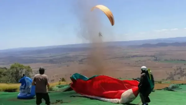
On clear, hot days it is common to get a layer very close to the ground that is superheated. This layer can be a few feet thick in green areas to several thousand feet thick in the desert. This layer is called the superadiabatic layer as mentioned previously. The superadiabatic layer has a lapse rate greater than the cooling rate of thermals, the DALR. As a result, the difference between the thermal temperature and that of the surrounding air is continually getting greater as the thermal rises through this layer. Thus the thermal accelerates upward. The figure below illustrates this principle. Thermals rising in a superadiabatic layer tend to be of smaller diameter, punchy and strong. They are most commonly experienced in the dry, sunny areas of the world. They also give rise to dust devils.
Source: Book Understanding the sky
— by Dennis Pagen