🌪️ Dust devils
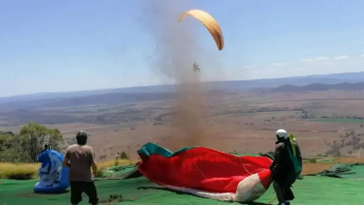
Tight cores of swirling wind will pick up dust, leaves and other debris to become a visible ground disturbance or towering column of brown dust in areas of bare ground. Such whirlwinds are known as willy-willies in Australia and dust devils elsewhere. Dust devils occur when a thermal lifts off in superadiabatic conditions. The air rushing in to fill the area below the thermal usually has some turning motion due to Coriolis effect if it has been flowing for some time. When this air comes together its spin is exaggerated just as a skater spins faster when his or her arms are brought in. This spinning air would soon lose its impetus except for the accelerating thermal "stretching" the air vertically and bringing the rotating column tighter as it gets higher, much like a column of thick syrup gets thinner as you pull the spoon out of it.
🌪️ How dust devils work
Dust devils are formed when thermals rise in a superadiabatic lapse rate. Dust devils lie under the rising thermal, mark its track, size and often height as well as duration.
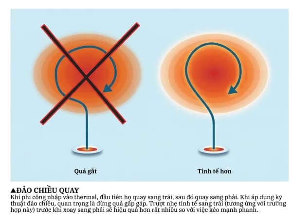
Dust devils sometimes reach up into a thermal cloud, but usually stop well below this level, being typically only several feet to several hundred feet high (up to 100m). In some desert areas however, they can tower over several thousand feet (1,000 m) when fine dust and strong continuous thermals abound. In these areas the height of the dust devil will indicate the minimum height of the thermal as well as its duration. However, at times the dust devil lasts past the production of usable lift as many unhappy pilots diving for a devil have found out. Watching the climb altitudes and rates as well as the duration of dust devils helps you judge the duration of the thermals creating them. The vast majority of dust devils turn counterclockwise in the northern hemisphere and clockwise in the southern hemisphere. They are low pressure phenomena. The few devils that turn in the opposite direction are probably artifacts of rotation that began through turbulence or moving past a bluff. There is some conjecture that dust devil action spins the thermal air, and indeed, rotating thermal clouds have been seen on a rare occasion. It is likely that the air continues to spin above the dust although it probably stops its spin due to drag when the thermal leaves the superadiabatic layer. On this basis, it is reasonable to expect a better climb rate when turning against the flow of the dust devil (clockwise or to the right in the northern hemisphere) when in the strong lift of the superadiabatic layer. The reason for this better climb rate against the flow in spinning air is your rate of circling is slower so less bank angle is required to offset centrifugal force. Less bank angle gives you a better sink rate. It is also important, to enter a dust devil thermal going against the flow for safety reasons. If you join the spinning air in the same direction as the flow you will experience a sudden strong tailwind which may stall you. If you enter against the flow you will experience an increasing headwind, as shown in the diagram below, which will provide improved maneuverability. A dust devil is a stable entity in that air from the outside cannot join the dust devil along the column and dilute it. Outside air can only enter it from below where the spin is slowed close to the ground as shown in the diagram below. The air on the outside of the column is spinning and rising as shown while inside the column downward flow can occur due to lowered pressure. An example of this action can be seen in a stirred cup of coffee with up flow on the outside and a depression in the middle. The center of the dust devil is generally clearer than the sides. The death of a dust devil occurs when the supply of warm air feeding the thermal is exhausted or some terrain effect blocks its progress. Dust devils will of course move up a steep mountain and are in fact quite common on heated slopes. A dust devil may continue a bit past the life of the thermal, but the devil soon looses energy and collapses. Witch doctors in Africa had a good business destroying dust devils by running through them, leaving the populace in awe of their demon-defeating powers.
The top view in the upper figure shows the track of a dust devil in relation to the wind. If a thermal moves with the wind or rises straight up above the ground wind layer it will be generally to the left of the dust devil track in the northern hemisphere and to the right in the southern hemisphere. This knowledge can help you locate thermals based on dust devils. The figure below shows how a dust devil snakes up to a thermal. Very tall dust devils can be seen to follow various undulating paths in different winds. The reason the dust devil travels at an angle to the wind direction is that the friction at the dust devil leading edge where it takes in the most air pushes it to the side. Dust devil strengths can be quite variable according to their size and rate of spin. Indeed some dust devils have blown apart house trailers just like tornados. Although dust devils look like mini tornados, they are caused by ground conditions and rise from the surface while tornados develop from instability aloft and come from the clouds down. A circulating wind of around 15 mph (24 km/h) in a dust devil 100 feet (30 m) across is typical and perhaps reasonable for sport aviation purposes. Using dust devils as thermal markers and sources of lift themselves is not without its hazards. Within the confines of the dust devil severe turbulence can be found (as well as a serious sanding of your leading edge). This turbulence has broken some aircraft and sent others out of control. These dire possibilities lead us to formulate the following dust devil safe flying rules:
🪂 Flying in a dust devil
- 🚫 Do not enter dust devils below 1000 ft above the ground.
- 🚫 Do not enter dust devils below the top of the visible dust.
- 🚫 Do not use excessively large and violent devils at lower altitudes.
- 🔄 Use a turn direction opposite to the dust devil spin.
- 🗺️ Locate a thermal based on a dust devil to the left (northern hemisphere) or right (southern hemisphere) of the dust devil path.
- 🆕 Newly formed dust devils are more reliable thermal markers than older ones.
Dust devils are most prevalent and powerful in desert areas. Some of these monsters can be 1/2 mile (1 km) or more in diameter. In greener areas dust devils are more rare, shorter lived and lower in extent. Part of this reason is the lack of dust to carry aloft. This author once flew in a thermal in Pennsylvania at 5,000 feet up with scores of corn leaves circulating in the thermal like a flock of hawks. We call this a leaf devil. On another occasion we witnessed a dust devil created on a rock outcropping in New Hampshire, that had no dust to pick up but made a sound on the rocks like fizzing fireworks. One other matter we should mention is water devils which occur when dust devil type swirls move over the water. These are usually short-lived and do not rise very high but they indicate good thermal conditions.
✨ Ideal thermal conditions
Air masses moving into an area play a great role in the stability and thus the thermal prospects. Warm fronts and warm air masses in general are not condusive to thermals because their load of humidity cuts down surface heating by scattering the sunlight. The humidity itself accepts heat directly from the sun and warms the air before thermals can develop. Cold air masses are generally good thermal producers. This is because they usually bring clear, dry air and become unstable when their under surface is heated. This isn't always the case as we have seen in the discussion of the sea breeze air mass which is stable. But cold fronts from the poles are almost always bearers of thermals. In the eastern US and northern Europe such fronts are welcome for the fine soaring they bring. Unfortunately they are also driven by high pressure systems and thus the trailing air mass is gently subsiding. The vigorous thermals push up through this sinking air, but they are slowed slightly. The real problem is that high pressure dominated air masses create inversions due to the subsidence of the air and thus a lid on thermals. For this reason it is normal in the eastern US for thermals to stop in the inversion around 6,000 feet (2,000 m) above sea level and 12,000 foot cloud bases are a rare, glorious sight. On the other hand, desert areas are in prime soaring form when a low pressure system sits over the area. The slightly rising air in the low reduces the stability aloft and aids thermal progress. It is not unusual for thermals to rise above 20,000 feet (7,000 m) in these areas because an inversion is usually not present. Most lows in the desert are heat lows. Lows are not often thermal producers in moister areas because their rising air creates clouds and rain. Pilots in green areas must settle for highs and lower altitudes. In moister areas dryer conditions are sought after. On the other hand in the desert a little moisture is desirable because the added humidity in the thermals helps make them lighter so they rise better higher up. Moister thermals also produce clouds which are great thermal indicators at altitude.
✨ What good thermal conditions look like
- Clear skies and bright sun
- Light to moderate winds
- Cold front, high pressure systems and dry days in moist, green regions.
- Low pressure systems and some moisture in desert regions.
🪂 Lift inside a thermal
Once an ideal thermal leaps into the sky and organizes itself it ideally takes on the shape of a mushroom turning itself inside out like a smoke ring as shown in the diagram below. The air rising in the core or center of the thermal is moving upward about twice the rate of the top of the thermal. Thus it is possible to be near the top and climbing slowly while other pilots are climbing up to you from below. It is not always their better thermaling skills at work in this situation, but their position in the faster rising air.
As the thermal rises it pushes the air above it up and out of the way creating sink and turbulence along the sides of the thermal. An area of turbulent mixing occurs at the leading edge of the thermal as shown. This sink and turbulent area are often what announces the thermal to a searching pilot. As our ideal thermal rises it continues to expand as it takes in more air and encounters lower pressure. It is fed from below as long as the supply of warmed air lasts and also pulls in air from the sides which may aid the thermal strength if it is a warm residue from a previous thermal or dilute the thermal if the air is cold. Some vortices and calves of the thermal are left behind in its wake as shown in the diagram below. It is probably a sure bet that the ideal thermal exists in nature judging from the thousands of pilot reports depicting textbook lift patterns in the thermal. However, there are also many occasions when cores are elusive, multiple and varying in strength. We'll look at the variety of thermals in nature in the next section.
📉 Thermal sink
In unstable conditions we know that lifted air wants to continue rising. We should also know that air given a downward push wants to keep moving down since it continually remains cooler than the surrounding air in an unstable lapse rate. This sinking air acts like a negative thermal. In good thermal conditions sinking air will be abundant. Usually the stronger the thermals the stronger the sink. However, because thermals inhabit typically 1/10 of the sky or less, the sinking air is usually more spread out and not as organized into strong vertical slugs. Interthermal sink is usually strongest higher up where thermals are larger and more able to start a wider area sinking. If thermals are organized by a mountain, other terrain effect or streeting action the sink can be also more organized and widespread. Sometimes the best policy when immersed in sinking air for a long time is to turn 90° to your course in hopes that you were flying along the long axis of a elliptical sink area and can thereby escape the sink.
📝 Summary
We seek to prolong our adventures aloft by hopping a free ride whenever we can. One of the best vehicles a soaring pilot can find is a thermal. These conveyances are like hot air balloons rising to the heavens. The only trouble is they are invisible for the most part. Thus we have to study their behavior so we can make the best guesses possible as to how, when and where to find them. Thermals are abundant and found practically everywhere at various times. They are variable in all their properties: strength, turbulence, size, duration reliability and height. Only experience, study and a little luck will afford you the ability to find the best thermal in the conditions at hand. We now have a good background in the basics of thermal behavior, ready to dive deeper into the fascinating world of thermal lore.
Source: Understanding the Sky (Dennis Pagen)
— By Dennis Pagen